Listen to this Post
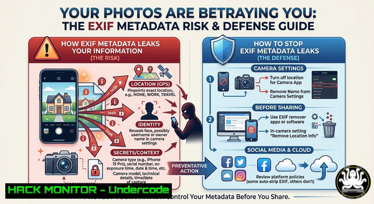
Introduction:
Every photo you share online carries hidden digital fingerprints—GPS coordinates, timestamps, device serial numbers, and even thumbnails of edited versions. This metadata, known as EXIF (Exchangeable Image File Format), is automatically embedded by smartphones, drones, and DSLRs. Cybercriminals and OSINT investigators exploit this data to geolocate targets, reconstruct movements, and gather intelligence. Understanding how to extract, analyze, and strip EXIF data is a core cybersecurity skill for threat intelligence, digital forensics, and privacy protection.
Learning Objectives:
- Extract and interpret EXIF metadata using free OSINT tools like Jimpl and ExifTool.
- Identify sensitive information (location, camera settings, software history) that can be used in attacks.
- Remove metadata from images before sharing to prevent unintentional data leaks.
You Should Know:
- Extracting Hidden Clues: Hands-On EXIF Analysis with Jimpl and ExifTool
The post highlights Jimpl Online EXIF Metadata Viewer (`https://jimpl.com`) and osintrack.com, a repository of OSINT tools. Jimpl allows you to upload an image or provide a URL to instantly view all embedded metadata without installing software. For deeper analysis and automation, professional investigators use ExifTool, a cross-platform command-line utility.
What EXIF typically reveals:
- GPS latitude/longitude (often down to 10 meters)
- Date/time original (establishing alibis or timelines)
- Camera make, model, firmware version (fingerprinting devices)
- Software used (e.g., “Adobe Photoshop CC 2024” – indicates editing)
- Thumbnail images (may show original pre-cropped content)
Step‑by‑step guide – Online (Jimpl):
- Navigate to `https://jimpl.com`
- Drag and drop a photo or paste its URL.
- Click “View Metadata” – examine the table for GPS, DateTimeOriginal, and MakerNotes.
- Use the “Remove metadata” button to generate a clean version.
Step‑by‑step guide – Command Line (ExifTool):
- Linux / macOS / Windows (with ExifTool installed):
Install ExifTool (Ubuntu/Debian)
sudo apt install exiftool

View all metadata from an image
exiftool -a -u -g1 suspicious.jpg

Extract only GPS coordinates
exiftool -GPSPosition -c "%.6f" image.jpg

Recursively scan a folder for images with GPS data
exiftool -r -if '$GPSLatitude' -filename -GPSPosition /path/to/photos/
-
Windows PowerShell (native, no install):
Using Shell.Application COM object (slower but built-in)
$shell = New-Object -ComObject Shell.Application
$folder = $shell.Namespace("C:\Photos")
$file = $folder.Items().Item("photo.jpg")
List property indices 0-300 (date taken = 25, camera model = 26)
0..300 | ForEach-Object { $value = $folder.GetDetailsOf($file, $<em>); if($value){Write-Host "$</em> : $value"} }
2. Weaponizing EXIF in OSINT and Threat Intelligence
Open Source Intelligence (OSINT) professionals actively scrape social media and forums for images. A single geotagged photo posted on Twitter or Telegram can reveal a soldier’s barracks, a whistleblower’s home address, or a corporate executive’s secret meeting location. The post mentions IMGINT – image intelligence – a discipline that combines EXIF extraction with reverse image search, landmark analysis, and shadow geometry.
How attackers use this:
- Physical targeting: GPS from a vacation photo → stalker knows when you’re away.
- Social engineering: Camera model + software version → tailor fake tech support scams.
- Forensic counter‑intelligence: Timestamps can disprove an alibi or confirm a leak.
Step‑by‑step guide – Batch geolocation extraction & mapping:
- Download multiple images from a target’s public album.
- Run ExifTool to generate a CSV of GPS coordinates:
exiftool -csv -GPSLatitude -GPSLongitude -DateTimeOriginal .jpg > gps_data.csv
- Use a Python script to plot on a heatmap (requires
pandas,folium):import pandas as pd import folium df = pd.read_csv('gps_data.csv') map_center = [df['GPSLatitude'].mean(), df['GPSLongitude'].mean()] m = folium.Map(location=map_center, zoom_start=12) for idx, row in df.iterrows(): folium.Marker([row['GPSLatitude'], row['GPSLongitude']], popup=row['DateTimeOriginal']).add_to(m) m.save('intel_map.html')
3. Metadata Stripping: Hardening Images Before Sharing
The simplest mitigation is removing all metadata. Jimpl offers a one‑click removal, but for automation or sensitive workflows, use ExifTool’s `-all=` tag to delete every metadata field. Be aware that some platforms (Facebook, Twitter) automatically strip EXIF on upload – but never rely on third‑party behavior. WhatsApp preserves location tags unless disabled in settings.
Step‑by‑step guide – Permanent removal & cloud hardening:
- Linux / macOS / Windows (ExifTool):
Remove all metadata from a single file (creates a backup) exiftool -all= -overwrite_original clean_photo.jpg Remove metadata from all JPEGs in a folder recursively find . -name ".jpg" -exec exiftool -all= -overwrite_original {} \; - Windows built‑in method (Properties):
1. Right‑click image → Properties → Details tab.
2. Click “Remove Properties and Personal Information”.
- Choose “Remove the following properties” → Select all → OK.
– Mobile (iOS/Android): Use apps like “Photo Metadata Remover” or enable “Save without location” in camera settings.
Cloud hardening for API uploads (e.g., AWS S3, Azure Blob):
If your application accepts user‑uploaded images, implement server‑side stripping to prevent stored XSS via metadata or legal liability. Example using Python Pillow:
from PIL import Image
img = Image.open('upload.jpg')
data = list(img.getdata())
img2 = Image.new(img.mode, img.size)
img2.putdata(data)
img2.save('clean_upload.jpg', format='JPEG', exif=b'')  Discard EXIF
4. Defensive OSINT: Auditing Your Own Digital Footprint
Organizations should regularly scan their public‑facing image assets (websites, social media, annual reports) for leaked metadata. Tools like osintrack.com aggregate viewers such as Jeffrey’s Exif Viewer, Metagoofil, and FotoForensics. A proactive audit includes:
Step‑by‑step guide – Company self‑audit:
- Crawl your own domain for image files (using `wget` or
gallery-dl):wget --recursive --no-parent --accept jpg,jpeg,png -P images/ https://yourcompany.com
- Run ExifTool recursively and flag any file containing GPS or author names:
exiftool -r -if '$GPSLatitude or $Creator' -filename -GPSPosition -Creator images/
- Remove flagged images from public access or strip metadata server‑side.
5. Legal and Ethical Boundaries in EXIF OSINT
Extracting metadata from publicly available images is legal in most jurisdictions (no authentication bypass required). However, using that data to stalk, harass, or target individuals violates computer misuse laws and platform policies. Threat intelligence analysts must always operate within the bounds of the target’s privacy expectations and organizational rules of engagement. Jimpl and ExifTool are neutral tools – the ethics lie in the usage.
What Undercode Say:
- Key Takeaway 1: EXIF metadata is a silent intelligence goldmine. Even “clean” photos from secure areas often retain GPS and device fingerprints. Always strip metadata before sharing in threat intelligence communities or public forums.
- Key Takeaway 2: Free OSINT platforms like Jimpl and osintrack.com lower the barrier to entry, but serious analysts should master ExifTool for automation, batch processing, and forensic integrity.
Analysis (10 lines):
Mario Santella’s post correctly emphasizes that simple image viewers can expose critical operational security failures. Many cybersecurity professionals focus on network‑level attacks (firewalls, SIEMs) while ignoring file‑level metadata. The Jimpl tool is user‑friendly for non‑technical users, but its real power is in rapid triage during an investigation. Osintrack.com serves as a curated toolkit, reducing time spent searching for reliable OSINT resources. The IMGINT hashtag highlights a niche but growing subfield – geolocation from images is often more accurate than IP geolocation. Attackers have used EXIF to bypass physical security (e.g., identifying restricted areas from employee Instagram posts). Defenders must implement automated metadata stripping in cloud upload pipelines and train employees on safe photo sharing. The post lacks specific command‑line alternatives, which we have supplied above to bridge theory into practice. Future iterations of AI‑based OSINT will automatically correlate EXIF data with satellite imagery and social graphs, increasing the risk exponentially. Organizations that ignore this vector will leak sensitive data through their most trusted medium: the humble photograph.
Prediction:
As generative AI tools (Midjourney, DALL‑E, Stable Diffusion) become widespread, attackers will begin embedding synthetic EXIF data into AI‑generated images to frame innocent individuals or poison OSINT datasets. Conversely, defenders will deploy AI‑based EXIF anomaly detection (e.g., inconsistent camera models with noise patterns). Within two years, we will see the first major breach where a threat actor used EXIF‑extracted GPS from a C‑suite executive’s selfie to coordinate a physical intrusion. Automated metadata stripping will become a default feature in all enterprise content management systems and messaging apps – not an optional setting. The arms race between metadata exploitation and counter‑forensics is only beginning.
▶️ Related Video (70% Match):
🎯Let’s Practice For Free:
IT/Security Reporter URL:
Reported By: Mariosantella Osint – Hackers Feeds
Extra Hub: Undercode MoN
Basic Verification: Pass ✅
🎓 Live Courses & Certifications:
Join Undercode Academy for Verified Certifications
🚀 Request a Custom Project:
Secure, high-velocity infrastructure and disruptive technological engineering. Contact our engineering team for high-tier development and proprietary systems:
[email protected]


