Listen to this Post
Introduction:
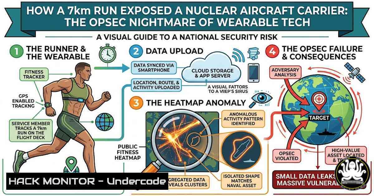
The intersection of consumer-grade fitness trackers and national security has once again proven to be a volatile fault line. In a stark reminder of the “Internet of Things” (IoT) privacy dilemma, a French naval officer inadvertently revealed the real-time location of the nuclear aircraft carrier Charles de Gaulle by publicly logging a 7-kilometer run on the deck using the Strava app. This incident echoes the 2018 Bellingcat investigation that exposed military bases via Strava’s global heatmap, highlighting that while technology evolves, the fundamental principles of Operational Security (OPSEC) remain critically vulnerable to human error.
Learning Objectives:
- Understand the technical mechanisms by which fitness tracking applications leak geolocation data.
- Identify the intersection of IoT data aggregation and national security vulnerabilities.
- Learn to implement OPSEC hardening techniques for both individual users and enterprise/IoT devices.
- Analyze metadata extraction and geofencing strategies to mitigate location-based risks.
You Should Know:
- The Mechanics of Location Leakage: GPS, Metadata, and Aggregation
The incident involving the Charles de Gaulle is a case study in how unsecured metadata becomes actionable intelligence. Fitness apps like Strava utilize Global Positioning System (GPS) data from a device (such as a smartwatch or smartphone). This data is typically stored in standardized formats like GPX (GPS Exchange Format) or FIT (Flexible and Interoperable Data Transfer).
When an officer logs a run, the application records a series of waypoints: latitude, longitude, timestamps, and sometimes heart rate or altitude. If the profile is set to “public,” this data is broadcast. To understand how easily this is extracted, consider how one might analyze their own data:
On Linux (using `gpsbabel` to convert and inspect GPX files):
 Install gpsbabel if not available
sudo apt-get install gpsbabel

Convert a GPX file to a human-readable text format to view coordinates
gpsbabel -i gpx -f activity.gpx -o unicsv -F activity.csv

Extract specific coordinates and timestamps
cat activity.csv | awk -F',' '{print $1, $2, $3}' | head -n 10
On Windows (using PowerShell to parse GPX as XML):
 Load the GPX file as XML
[bash]$gpx = Get-Content -Path "C:\Users\Path\activity.gpx"

Extract all trkpt (track points) for analysis
$gpx.gpx.trk.trkseg.trkpt | Select-Object lat, lon, time | Export-Csv -Path "coords.csv" -NoTypeInformation
Step‑by‑step guide:
This process demonstrates how a malicious actor (or security auditor) can take a public activity file, convert it to structured data, and map the precise path. If that path is on a military vessel at sea, the geographic coordinates confirm the ship’s location, speed, and heading. In this case, the “run” was confined to the flight deck, a limited space roughly 260 meters long, making the GPS trace unmistakably a ship at sea rather than a land-based track.
- OSINT Reconnaissance: From Public Profiles to Strategic Intelligence
Open Source Intelligence (OSINT) is the art of collecting publicly available data to build a target profile. In the context of the Strava leak, a malicious actor doesn’t need to hack the device; they simply need to scrape the platform.
A common technique involves using the Strava API or third-party aggregators to search for keywords like “Navy,” “Military,” or specific base names. However, the most dangerous leaks come from linking personal accounts to professional identities. In this case, the officer’s profile likely contained identifiable information connecting them to the French Navy.
Command-line example (using `curl` to interact with a public API for location scraping – for educational purposes only):
 Simulate a request to a fitness API (requires developer tokens in real scenarios)
curl -X GET "https://www.strava.com/api/v3/athlete/activities?access_token=YOUR_TOKEN" -H "Content-Type: application/json"

Using jq to parse JSON output for specific location tags
curl -s "https://example-osint-source.com/user/123" | jq '.activities[] | {start_latlng, map_summary_polyline}'
Step‑by‑step guide:
This vulnerability exists because there is no “geofence” that automatically redacts coordinates when a user enters a classified area. In a secure environment, administrators should implement Data Loss Prevention (DLP) policies that block fitness app traffic or use Mobile Device Management (MDM) to disable GPS functionality on premises. For individuals, the solution is to set profiles to “private” and use the “Privacy Zones” feature available in Strava and Garmin, which allows users to mask the start and end points of activities (effectively hiding the ship’s dock or home base).
3. Mitigation Strategies: Hardening the IoT Perimeter
To prevent such leaks, a layered security approach is required. This involves technical controls, policy enforcement, and user education. The French Navy will likely update its “Security Classification” policies to explicitly prohibit the use of personal wearable devices on duty.
Linux Command for Network-Level Blocking (using `iptables` to block fitness app domains):
 Block Strava API endpoints at the firewall level
sudo iptables -A OUTPUT -p tcp -d www.strava.com -j DROP
sudo iptables -A OUTPUT -p tcp -d strava.com -j DROP
sudo iptables -A OUTPUT -p tcp -d api.strava.com -j DROP

Save the rules
sudo iptables-save > /etc/iptables/rules.v4
Windows Firewall Command (using `netsh` to block IP ranges associated with tracking services):
 Block an outbound IP range (example: if you know the cloud provider IPs used by the app)
netsh advfirewall firewall add rule name="Block Strava" dir=out action=block remoteip=192.0.2.0/24 protocol=any
Step‑by‑step guide for Corporate OPSEC:
- Inventory Devices: Use MDM solutions (like Microsoft Intune or Jamf) to enforce GPS disabling when connected to corporate or secure Wi-Fi networks.
- Application Whitelisting: Restrict the installation of fitness apps on corporate-owned devices.
- Data Classification: Train personnel to treat location data as “Controlled Unclassified Information” (CUI). Any activity that reveals the operational footprint of a vessel or base should be classified at a level that prohibits public sharing.
- Geofencing: Implement mobile security software that automatically disables camera and GPS functionalities when entering a designated “secure zone” (e.g., a naval base perimeter).
-
The Role of AI in Analyzing Aggregate Data
While the French officer’s mistake was a single point of failure, the 2018 heatmap incident demonstrated the power of AI and big data analytics. Machine learning algorithms can identify patterns in aggregate data that a human would miss. For instance, an AI model can classify an unusual GPS path—such as a repetitive rectangular loop at sea—as a naval vessel.
Python Script Snippet for Anomaly Detection (simulating AI analysis of GPS data):
import pandas as pd
import numpy as np
from sklearn.cluster import DBSCAN

Load GPS data
data = pd.read_csv('gps_points.csv')
coords = data[['lat', 'lon']].values

Use DBSCAN to cluster points; noise points (outliers at sea) might indicate a ship
clustering = DBSCAN(eps=0.001, min_samples=10).fit(coords)
data['cluster'] = clustering.labels_

Identify noise points (label = -1) that are not on land (simplified logic)
anomalies = data[data['cluster'] == -1]
print(f"Potential operational security breaches detected: {len(anomalies)}")
Step‑by‑step guide:
This script shows how an intelligence analyst could use unsupervised learning to flag anomalous activity. By aggregating public data from thousands of users, AI can identify “outlier” tracks that do not align with road networks or urban geography—essentially mapping restricted military zones and their operational cycles.
5. API Security and Third-Party Integration Risks
Fitness apps rarely exist in a vacuum. They often integrate with other services (e.g., Zwift, MyFitnessPal, or even LinkedIn). The officer’s data may have been exposed through a third-party API that had weaker privacy controls. If an API endpoint is misconfigured (e.g., allowing unauthenticated access to user activity streams), the data becomes vulnerable.
Testing for API Exposure (using `curl` to test for CORS misconfigurations):
 Check if an API endpoint leaks user data without proper authentication
curl -X GET "https://api.fitnessapp.com/v1/users/123/activities" -H "Origin: https://malicious.com"
 If the response includes 'Access-Control-Allow-Origin: ', it is vulnerable to data scraping.
Step‑by‑step guide for API Security:
Developers and security architects must enforce OAuth 2.0 with strict scope limitations. If a military organization uses a fitness app for morale, they must configure the API to reject any request that does not originate from an approved, MDM-controlled device with a specific hardware token.
What Undercode Say:
- Human Error is Unstoppable: The most sophisticated encryption is irrelevant if a user manually overrides privacy settings. Security awareness training must be continuous and scenario-based, not just a one-time onboarding module.
- Metadata is the New Battlefield: This incident confirms that in modern intelligence gathering, metadata often contains more actionable intelligence than the content of a communication. Defending the “perimeter” now includes defending the location trails of personnel.
The recurrence of this issue—from 2018 to 2026—indicates a systemic failure in integrating personal tech policies with national security frameworks. Organizations cannot rely solely on platform updates from companies like Strava; they must implement active, technical controls at the device, network, and policy levels. The use of AI to scrape public datasets for geospatial intelligence will only increase, turning innocent fitness data into strategic military intelligence. Until “privacy by default” becomes a legal standard for wearable technology, and until military personnel are equipped with technology that physically cannot transmit location data from secure zones, these leaks will continue to occur with potentially catastrophic consequences.
Prediction:
In the next five years, we will see a rise in “Geo-AI” legislation requiring fitness and IoT platforms to automatically implement geofencing around military and critical infrastructure zones. Furthermore, advanced nations will likely deploy “Spoofing Zones” around sensitive assets, broadcasting false GPS data to fitness apps within a perimeter while maintaining accurate internal navigation, effectively rendering leaked data useless to adversaries.
▶️ Related Video (78% Match):
🎯Let’s Practice For Free:
IT/Security Reporter URL:
Reported By: Olliebone I – Hackers Feeds
Extra Hub: Undercode MoN
Basic Verification: Pass ✅


